


Fully sunny and dry for Saturday. Temps will be above normal. It will be a good day with good evaporation. This will be the best chance of field work in this forecast. Sunday will see clouds. Overnight Saturday night into Sunday morning we can’t rule out a few hit and miss showers over the northern half of the state, but really we see no more than a few hundredths to a tenth. Rains start to build back into SW Indiana late Sunday afternoon and evening.
Overnight Sunday night through Monday we have showers and a few thunderstorms that can bring .25”-1.5” rain totals with coverage at 80% of the state. The heaviest action will be with thunderstorms and those look most likely in central IN, but we will not limit their spread or scope at this time.
Tuesday forward through the rest of the week we have a chance of scattered showers every day. Daily coverage will be no better than 60% on most days but may reach 80% on Thursday. Daily totals range from a few hundredths to .5”, and for the week combined, the rains can add an additional .25”-1.5” to what we see Sunday night through Monday. The map below shows rain potential for the 10 day period as a compared to normal. All of us are expecting above normal moisture potentially. Remember our comment above that moisture could be more than the totals we are projecting in the paragraphs above, and we hope they are less….time will tell. The key here is that we all won’t see rain every day…but there are chances over the state, and even if you miss rain on one or more days, with the set up, we will not see any wholesale drying for the week.
Sunday may be dry for the daytime hours, but a chance of showers returns overnight Sunday night into Monday.

Tuesday and Wednesday, the 25th and 26th we should see some drier air. But, showers are back for Thursday the 27th with .1”-.4” potential. We go sunny and dry for the 28th through the 31st.
Weeks 3 & 4:
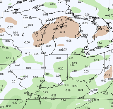
Slightly more active precipitation will be found over the region for week three, as we see normal to slightly above normal precipitation for the week. We dry down in week 4 and may be able to squeeze out a totally or mostly dry week there as we head toward mid-June. Temps for both weeks suggest we have finally shaken off the cold air, and we should be well above normal both weeks.
Week 3
Precipitation (green: above normal, brown: below)
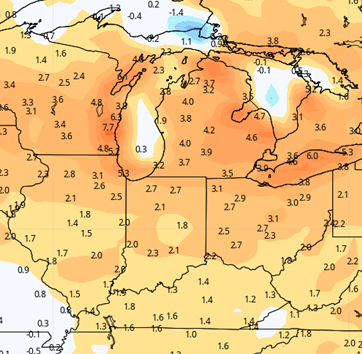
Week 4
Precipitation (green: above normal, brown: below)


