The harvest forecast continues to present some challenges for field work over the next 10 days, but this forecast is not as wet as our last one. We are starting off damp, as a significant frontal boundary complex will continue to move off to the northeast through Saturday. We likely see some lingering showers over Indiana, especially north, through Saturday. Additional moisture will be on the order of a few tenths, and central to southern Indiana will likely start to dry out sooner on Saturday.
Strong north flow will dominate Sunday through Tuesday. These north winds coming right over the Great Lakes will provide ample “lake effect” cloud cover, and we won’t be able to rule out some isolated showers or sprinkles. However, most of that moisture will be in areas close to or down wind of the lakes. Elsewhere, colder temps will keep drying a bit slower, but winds will try and make up for the lack of evaporation potential just a bit.
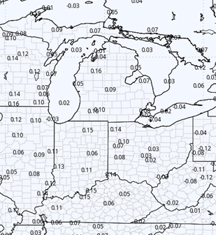
Wednesday, we turn out partly sunny and warmer. However, our next front is on the move. It arrives Thursday with scattered showers. This front is much more insignificant than this past one…and as such we expect only a few hundredths to .4” with 60% coverage.
Behind the front on Friday, we clear out over the northern part of the state. However, we are seeing a low develop over the MO valley Thursday with moves into the OH and TN valleys Friday into Saturday. It has a clean path to moisture off of the Gulf, so we are introducing the threat of rain into southern and southwest IN Friday midday and afternoon.
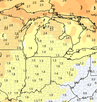
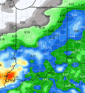
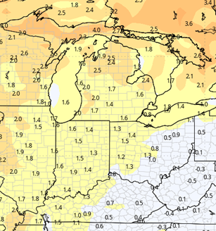
The low lifts northeast and can drive showers into east and even NE IN and all of OH overnight Friday night and Saturday. Rain potential looks to be .25”-.75” with coverage at 60% of Indiana, but that coverage is limited, at least right now, to the areas we mentioned. North central, NW and west central IN likely see no rain on the current track, but we continue to watch it. The map below is a preliminary snapshot of system track and moisture potential.
That moisture will be hanging around to start the weekend on the 21st, but we clear out quickly for the 22nd, and stay sunny and dry into the first couple of days of the week of the 23rd.

Extended Period:
The entire extended 11-16 day forecast window is dry on this new look. This will allow us to see a good harvest window from the period right behind that Ohio Valley system on forward. While we will be dry, we will only be seasonal on temps…meaning we are cooler, and drying may be a little slow at the start, depending on what locations see for rain totals this coming Friday-Saturday.
Weeks 3 & 4:
Precipitation continues to look near normal over weeks 3 and 4, however we are leaning toward a slightly drier week 3 on carry over from the 11-16 day dry trend. The Ohio Valley and deep south look wetter into Week 4, and that may set the stage for slightly wetter pattern liftin up from the south over the second half of the month of November. Temps remain just a touch above normal (a degree or two) on a weekly average through mid-November.
Week 3
Precipitation (green: above normal, brown: below)
Temperatures (blue: below normal, orange: above)
Week 4
Precipitation (green: above normal, brown: below)
Temperatures (blue: below normal, orange: above)