
A wet start to this harvest forecast this time around, but we also have a very dramatic change in airmass to talk about. Ultimately, that change in airmass also leads to a dry window over most of the state.
A frontal boundary is set to move through the eastern corn belt from Saturday night through Monday morning. Ahead of the frontal passage, we continue to see a bit of hit and miss moisture for Saturday morning, midday and afternoon. Coverage on that hit and miss stuff is minor…at 40-50% maximum.
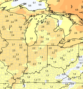
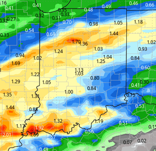
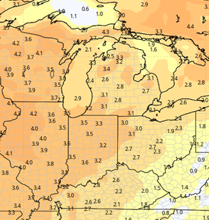
The real fireworks get going Saturday night. Showers and storms move across all of Indiana Saturday night and continue on Sunday with 2 general waves. Rains can be moderate to heavy, and there is good thunderstorm potential, at least over some parts of central Indiana. Action ends first in NW Indiana late Sunday afternoon, but showers may hold on into Monday morning in far southern Indiana. Rain totals for the entire frontal passage from Saturday morning through Monday morning will be .25”-2” with coverage at 100% of Indiana. The map below shows the rain totals and spread.
The front is even more impressive when it comes to airmass change. We have much, much colder air racing in behind the front overnight Sunday night and Monday. Clouds likely keep us above freezing Sunday night, but we turn out chilly Monday through Thursday with consecutive hard freezes each night. This will be a definitive end to the growing season. Daytime highs Tuesday through Thursday will be limited to the 40s. Overnight lows in the mid-20s. We see temps start to moderate Friday afternoon, and then we are much warmer for next weekend.
In this cold surge and then subsequent warming, one thing is clear: WE ARE DRY! We see no new significant moisture coming through, no fronts. We do have strong north flow over the great lakes and a minor disturbance moves through MI and southern Ontario Wednesday. However, this likely just triggers lake effect clouds, and nothing of significance on moisture. We are projecting a fully dry period from Monday afternoon on through next Monday. Sunshine will help drying, although evaporation will be limited somewhat by cooler temps. Still, we think that there is a very good opportunity to get back to field work by midweek at the latest, and we should have a nice dry pattern heading into the following week.

Extended Period:
For the entire extended 11-16 day forecast window we have rain showers returning with a minor system for Tuesday the 7th. Right now, we are projecting rain totals of up to .6” with coverage at 60%. Behind that system, we are cool, but seasonal, and sunshine returns. We are dry from Wednesday the 8th all the way through Sunday the 12th.
Weeks 3 & 4:
Near normal precipitation in weeks 3 and 4, meaning we likely see at least 1 frontal passage or system each week. Temps will bounce back after the cold this coming week, and will be above normal each week, on average 2-3 degrees above the normal average weekly temp. Remember, though, normal temps are falling quickly each week anyway!
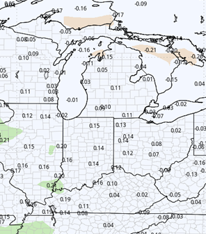
Week 3
Precipitation (green: above normal, brown: below)
Temperatures (blue: below normal, orange: above)
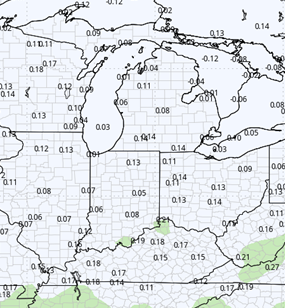
Week 4
Precipitation (green: above normal, brown: below)
Temperatures (blue: below normal, orange: above)