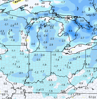
Cold air is the first the topic of discussion in this weeks supplanting forecast period. We are looking at well below normal temperatures for this entire weekend, and we are also going to be seeing a redevelopment of cold air about a week from now. In the meantime, there is plenty of moisture still hanging around, especially over central and northern Indiana and up into Michigan through this week. We do see a slight break in the action, maybe putting together three to four days back-to-back to back that we might possibly use to get into the fields. That would be early next week. However, this pattern is highly unstable, and can change on a whim. Still, we are expecting plenty of moisture over the next 10 days. The map at right shows moisture through this coming weekend, and we will go through that in our narrative below.

Starting with this weekend, temperatures continue to be well below normal. Frost and freeze conditions are dominating the landscape Saturday morning into Saturday midday. We should see good sunshine through Saturday afternoon, and decent sunshine on Sunday at least through early afternoon. Temperatures on Sunday will be a little bit milder than what we expect for Saturday, but by no means will we be warm.
Overnight Sunday night through Monday and Tuesday we see multiple rounds of moisture. The first rounds are hit and miss; Sunday night, they’ll be in Northern Indiana and Michigan, Monday through the day, central and Southern Indiana. However, as we move through Tuesday afternoon and evening, we will be seeing significant rains come in from the west and southwest. Those will move across all of Indiana, Ohio and central to southern Lower Michigan. Right now we expect rain totals over the combined two and a half day stretch (Sunday afternoon/evening through sunrise Wednesday) to be anywhere from a quarter to at least 1 inch with coverage at nearly 100% of Indiana, likely 75% of Michigan and probably 100% of Ohio. 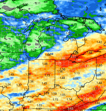
The rest of next week, Wednesday afternoon through Thursday and Friday, we are chilly again as temperatures pull back. In that cooler air we’re mostly dry, but we won’t rule out a little bit of moisture, particularly as we for later Friday into early Saturday. There I think we can pick up another half an inch of rain over most of the Great Lakes region. We may rule out some of the areas far northern Michigan and up into the UP, but you get the idea. Large part of the Eastern Corn Belt gets moisture to finish this coming week.
Mother’s Day weekend is a little drier now. We had been talking about some moisture developing, but we’re going to be tabling that talk just a little bit. Mixed clouds and sunshine for the weekend, but still not an overwhelming surge in temperatures to the high side. The week of the 11th is where we see this potential for a slightly better dry window, at least in Indiana and far southern MI. we are not projecting significant moisture for the 11th through the 14th period in those areas. However, Wednesday the 13th looks potentially stormy in central and northern MI, along with the Upper Midwest. We will have to watch that moisture set up for any hint of drifting south.
Extended Period:
Heading into the extended forecast window, we are going to be seeing another round of moisture. Now, this part of our forecast though is subject to change. As we’ve kind of mentioned, the pattern is highly unstable and it won’t take much to get some moisture to come in, especially with bigger swings in temperature like we’re trying to see. In any case, significant rain and thunderstorm activity will be coming together early on the 15th. We might even see it drifting back into late the 14th, and this will be a pattern that continues on into the following weekend. We are looking at rain totals anywhere from half to 1 1/2 inches, with coverage in at 100% of Indiana and Michigan. Going forward into the final part of that extended window, getting into the 17th, 18th, we are seeing a slight drier surge from the north and northwest.
Weeks 3 & 4:
Normal to above normal precipitation is expected for week 3, normal for week 4. That means we may have some continued trouble drying over the region. Temperatures remain easily below normal both weeks, adding to the slower drying potential.
Week 3 Precipitation: 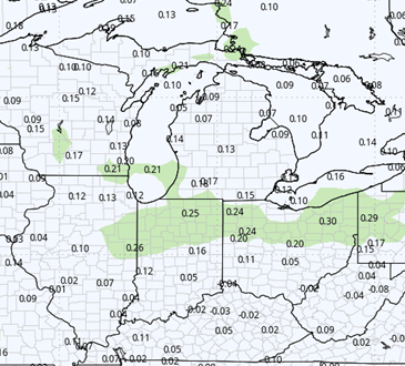
Week 3 Temperature: 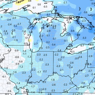
Week 4 Precipitation: 
Week 4 Temperature: